


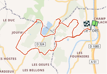
Reco 1er Rando BF 2022

claude nier
User

Length
13.2 km

Max alt
724 m

Uphill gradient
317 m
Km-Effort
17.4 km

Min alt
581 m

Downhill gradient
316 m
Boucle
Yes
Creation date :
2022-05-18 09:01:01.459
Updated on :
2022-05-18 17:04:39.785
5h11
Difficulty : Medium

FREE GPS app for hiking
 SityTrail
IGN / Geographical institutes
SityTrail Plus
The world is yours!
About
Trail Walking of 13.2 km to be discovered at Provence-Alpes-Côte d'Azur, Hautes-Alpes, Le Poët. This trail is proposed by claude nier.
Description
Reco faite avec Jp
Photos


Positioning
Country:
France
Region :
Provence-Alpes-Côte d'Azur
Department/Province :
Hautes-Alpes
Municipality :
Le Poët
Location:
Unknown
Start:(Dec)
Start:(UTM)
731168 ; 4908385 (31T) N.
Comments